This article is an excerpt from NauticEd’s online Skipper Large Keelboats Course, a comprehensive online sailing course for beginner to intermediate sailors to learn how to sail large sailboats 26 ft (8m) and above. The Skipper Large Keelboats course is part of the Skipper Course Bundle of online courses, also teaching you how to master maneuvering under power and docking!
You can learn to sail and improve your sailing with NauticEd, the international leader in sailing education.
Weather Predictions
While we have touched on weather concepts in this Module, no one can expect you to be a meteorologist (unless you are one) and do a good enough job at predicting the weather with enough quality to guarantee your safety. Weather maps are easily attainable from many sources. But again, how well can you read them?
Observing a Weather Map
By learning to read a weather map – you can gain a lot of good general knowledge about coming weather conditions.
Here is a typical situation in the northern hemisphere.
And here is a typical situation in the southern hemisphere. You’ll notice that the weather systems spin in opposite directions in the opposite hemisphere. This is due to a phenomenon called Coriolus.
Predicting the Weather with High Accuracy
While Cook was discovering the Pacific in the 1700’s, he was at least a year away from any outside information. Storms came and went and with experience and prudence, he and his crew were able to survive. They brought valuable information back to the Royal Astronomical Society regarding the local time of day at which Mercury transited the Sun on Nov 9th, 1769 in the now-named Mercury Bay in New Zealand. From that information combined with other matched sightings, the Royal Astronomical Society was able to calculate the size of our solar system with surprising accuracy. Incredible!
The point is that Cook would have given anything to have information that we almost take for granted these days.
Before modern-day digital forecasting and its cool electronic toys like Doppler radar and satellite imaging, sailors feared the weather on every outing, and rightly so. Bad weather and death were potentially always just around the corner. Today, cool toys tell us just about everything. But that means that the modern-day sailor must use and understand how to use the cool toys. There is no room on earth for the lackadaisical recreational sailor who goes out on the water without checking the tools at hand to gain an accurate weather forecast. Cook would have been ashamed of you if you did.
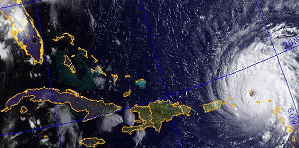
Philosophers have repeatedly said: that we all talk about the weather, but there are very few things we can do about it. While this is still true today, we have real-time knowledge about approaching weather conditions, thus allowing us to be better prepared. Gone are the days when a hurricane will hit without warning. In September 1900, 8,000 people were killed in Galveston, Texas, during a category 4 hurricane. They simply did not know it was coming, nor did they have time to get out of its way. Now we have the ability to make smart decisions; even choosing to not go out sailing today – or even waiting until this afternoon when it will clear.
Below is Hurricane Irma in 2017 crushing the BVI.
Today, information about weather conditions is updated in real time and made available to every mariner. Even at sea, mariners can get instant information via satellite. Even better, computer weather forecasting models are mature and predictions are accurate. Everybody has their own favorite personal weather anecdote, based on aching joints or running noses, about what the weather will be like. These folk tales should not be taken too seriously, but weather forecasts should.
Weather Forecast Terms
| Gale Warnings | Average wind is expected to be F8 or more or gusts 43-51 kn |
| Strong Wind Warnings | Average wind is expected to be F6-7. F6 is often called a yachtsman’s gale |
| Imminent | Within 6 hours of the time of issuing the warning |
| Soon | Within 6-12 hrs of the time of issuing the warning |
| Later | More than 12 hours from the time of issuing the warning |
| Visibility | GOOD = greater than 5 miles (8km) MODERATE = between 2 to 5 miles (3.3 km to 8km) POOR = 0.6 miles to 2 miles (1km to 3.3km) FOG = less than 0.6 miles (1000m) |
| Fair | No significant precipitation |
| Backing | Wind changing in an anticlockwise (counterclockwise) direction. e.g. from NW to SW |
| Veering | Wind changing in a clockwise direction. e.g. from NE to SE |
| General Synopsis | How and where the weather systems are moving |
| Sea States |
Wave heights: |
Weather Information
Nowadays, sources of weather information are virtually limitless. There is no excuse, and it is an amateurish mistake, to be caught out unawares by the weather because you did not bother to look. Yes, you might be miles out to sea when a weather system develops or a tropical depression turns in your direction. But for the most part, these are still predicted by the weather models. Using the proper tools, you will know it is coming whereby you can form a tactic to outrun it prior to its arrival. Cook, Drake, and Magellan had no such luxury.
Here are the major sources of weather information:
- VHF radio, fixed mounted or handheld
- On-line Internet access
- Weather fax
- Television and radio stations
- Streaming audio on the internet. For USA use NOAA Weather Radio
- Smartphone and Device Apps
- Subscription services for serious sailors wanting accuracy
VHF Radio
Tuning into one of the local VHF weather channels designated for your area will provide a local forecast as well as for close surrounding areas. This information is updated and repeated continually, 24 hours a day. A quick search on the Internet will give the VHF channel for your local area.
The Internet
Weather information is constantly gathered, updated, and disseminated by a vast number of websites. A quick search will render ones to your liking. Here are some common USA and global ones:
Apps
PocketGrib
A quick and easy App for weather information is called Pocket GRIB. This clever app downloads on demand an extremely small GRIdded Binary (GRIB) file and overlays into the software in the App. You can select anywhere in the world for which you want the information and you get a forecast up to 5 days. The reason it is so cool is that the data packet is extremely small which saves on cell data rates if you are in a place where you’re using roaming data.
Tap the image for an animation. Notice that as the animation plays the conditions change with date and time. It ends with a tabular view of the same. Watch it a few times.
Pocket Grib Animation
- PocketGrib for iPhone
- PocketGrib for iPad
- PocketGrib for Android
Wunderground
Besides being a good website, the WunderGround App – WunderMaps is also pretty good. It uses the internet directly to present information.
Here is a screenshot of the WunderMaps App showing radar and frontal systems.
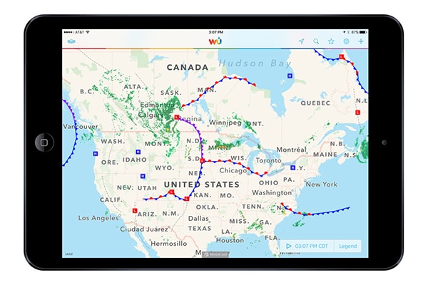
WunderMaps App
Windy
Windy is a good website with an associated App to view wind flow animation with speed and other weather data.
Predict Wind
We saved the best for last. Predict Wind is the App used by professional sailors racing globally and locally. It is designed for sailors by sailors (and meteorologists of course). But it can also be used for just general detailed weather prediction for any reason. Predict Wind also shows weather information on their website once you sign up (for free). Your sign-up account ties to your App account so whatever level you sign up for, you have that information cross-platform available to you. They have free and paid for subscriptions.
And here is a bonus surprise for you. As part of your NauticEd membership, you receive 3 free months of the professional version of Predict Wind.
To claim your Free PredictWind subscription follow these 3 steps.
- Click On the link here
- Enter your details and the Promo code nautic1220
- Download the Free PredictWind App or Offshore App by following the link here
The Full help center for PredictWind can be found here:
If you have any issues claiming your PredictWind subscription or for general product support
please tap on the Support button within the PredictWind app or email support@predictwind.com
The reason that we feel this is the best app is the depth of information available from the world’s top weather models with an easy user interface. Here is a Podcast we recorded with Predict Wind.
If you’re not convinced yet about Predict Wind read the blog we posted regarding Predict Wind here
What we recommend
Sign up for Predict Wind now and have a play around. The user interface is pretty obvious and there are plenty of user support articles if you get stuck.
For Skipper Small Keelboat purposes we recommend at a minimum (after your Professional version expires) that you maintain the Basic membership at a crazy ridiculous price of $29 per year. At this membership level, you will get the imperative pieces of information for sailing in your local area.
Basic Version Advantages over the Free Version
- 1 km Resolution maps (means highly accurate data)
- CAPE maps (helps predict thunderstorms)
- Gust Maps
- Real-time wind observations
- Forecast Alerts
See all the Pricing and packages here
The bottom line is that the weather we sail in is seldom stable. But forecasts are highly accurate. Sailors need to use the technology and also be constantly alert to changes.
You can learn more in the Skipper Course....
Knowledge and theory for longer distances and overnight sailing in diverse conditions. The Skipper Course is a comprehensive online sailing course for beginner to intermediate sailors wanting to learn how to sail larger sailboats 26ft to 56ft. Or upgrade to the Skipper Course Bundle of online courses to also master maneuvering under power and docking!