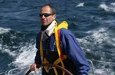
This article is an excerpt from NauticEd’s online Skipper Large Keelboats Course, a comprehensive online sailing course for beginner to intermediate sailors to learn how to sail large sailboats 26 ft (8m) and above. The Skipper Large Keelboats course is part of the Skipper Course Bundle of online courses, also teaching you how to master maneuvering under power and docking!
You can learn to sail and improve your sailing with NauticEd, the international leader in sailing education.
Understanding Weather Systems
Weather is a highly complex natural phenomenon. Globally, it is all connected and operates on a multitude of physical laws. Consider these few that constantly bewilder and wonder us:
- Heat travels through space from our very own star at the speed of light.
- Warm air rises while cold air sinks.
- Air wants to flow from high pressure to low pressure.
- Pressure decreases with altitude.
- Warm water releases vapor faster than cold water.
- Warm air holds more moisture than cold air.
- The Coriolis effect turns the wind right in front of our eyes.
- The tilt of the Earth creates the seasons.
Predicting weather is one of humankind’s most challenging tasks because of the many variables. It is indeed fickle stuff; it can be almost motionless one moment and moving rapidly with tremendous speed and force the next. While there is not an app yet to control the weather, the good news is that there are now many good sources to accurately predict the weather. These sources present graphical and table formats of the weather predictions conveniently on laptops and on apps. Soon, we will give you some good apps to play with.
Meteorology is the science of weather, and while forecasting weather is not yet an exact science, it is getting mighty good. Before going sailing, be sure to obtain the very latest weather conditions for your local area and predictions for the period you will be sailing.
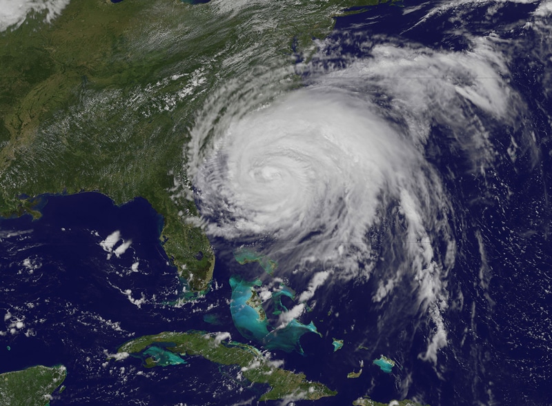
A Hurricane off the SouthEastern US Coast.
Weather Sources
Global weather in general comes from unequal heating of masses of air at the Earth’s surface in places called “source regions.” The main source regions are the snow-covered Arctic and Antarctic plains and tropical and subtropical oceans. Thus, an air mass might be cold and dry, cold and moist, warm and dry, or warm and moist. As the air moves, the planet rotates underneath it. This causes the rotation that we see on weather maps every day.
Air masses at different latitudes move around the planet in different directions. This is because, at the equator, air is generally ascending. As surface air moves in to replace the ascending air, it turns west. In the polar regions, the air is generally descending. As air at the surface is pushed away from the polar region, it turns east. Due to other more complicated effects, that is, rotation and tilt, air from the equator descends back to the surface at about 30 degrees north and south latitudes. At 60 degrees north and south latitudes, air rises to descend again at the polar regions. This is called the Three Cell Model of General Circulation.

Three-Cell Model of General Circulation
It’s not necessary to remember all this detail but only to say that all these forces and movements create general trade winds, which sailors have been using for thousands of years. It’s why cruisers go around the world in an east-to-west direction, sticking to more equatorial latitudes with easterly winds and racers go around the world in a west-to-east direction going as far south as possible with westerly winds. These forces and movements also create clashes of spinning air masses. It is these clashes that affect local conditions creating cold and warm fronts and pressure gradients.
|
Factoid A westerly wind comes FROM the west |
When a cold low-pressure mass of air clashes with a warmer mass of moist air things are going to happen like frontal systems, which will be discussed soon.
Pressure
Air pressure is essentially the weight of all the air above an imaginary column of air pressing down. It is dependent on the density of the air and the temperature of the air in the exact column above. On a weather map, you see lots of circular and curved lines. These are isobars—lines of similar pressure. They are akin to gradient lines of similar height you see on a contour map showing mountains.
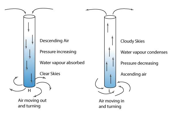
High-pressure areas, “highs”, are normally caused by a phenomenon called subsidence, meaning that as the high-altitude air in the high-pressure zone cools it becomes denser and moves toward the ground. Pressure increases here because of the dense air above. As the dense air approaches the ground it moves out and away towards lower pressure areas. As the air becomes denser, it can hold more water vapor. So high-pressure systems are usually associated with clear skies and relatively calm weather.
A high-pressure system is an area where the atmospheric pressure is greater than that of the surrounding area. In some places, highs are referred to as anticyclones. The descending air moving out and away as it approaches the ground moves clockwise in the northern hemisphere and counterclockwise in the southern hemisphere due to the Coriolis effect (explained below).
A low-pressure system, or “low,” is an area where the atmospheric pressure is lower than that of the surrounding area. Lows are usually associated with high winds with moist warm air moving to the center of the low. As the air moves toward the center of the low-pressure area it rises and thus atmospheric lifting occurs. As air rises, it holds less water vapor and releases the water vapor in the form of droplets. Droplets gather and rain occurs. Because of this, lows normally produce clouds, precipitation, and other bad weather such as tropical storms and cyclones.
To gather some perspective, pull the plug on your bathtub and a cyclone of water appears sucking water down the plug hole. While Coriolis may instigate the spin in the water it is the angular momentum of water rushing in feeding on itself that makes the water spin faster and faster. This is akin to a large atmospheric low-pressure zone or destructive cyclone. Conversely, if you pumped water up the plughole into the bathtub, nothing dramatic would happen except the water level rising. This is akin to an atmospheric high-pressure zone and a lovely day outside under a blue sky.
Since low-pressure systems are referred to as cyclones, high-pressure systems are referred to as anticyclones.
As one might expect, wind likes to flow from high pressure to low pressure. But notice the words “like to.” What actually happens is that while wind is moving the Earth also turns, creating an effect on the wind called the Coriolis effect. This changes the wind’s flow direction and results in a large circular motion about the pressure center. High-pressure systems spin one way and low-pressure systems spin the other depending on whether they are situated in the northern or southern hemisphere.
As you get closer and closer to the center of a low, the pressure is dropping. This can be measured by a barometer. The lower the pressure the more propensity the wind has to move to the center of the low and the more the angular momentum of the wind feeds upon itself—which means higher wind speed (remember the high speed plug hole water). If you see the pressure dropping below 1000 mbar (millibars) then a low is approaching. Pressure in hurricanes gets down in the low 900 mbar range. Hurricane Irma in the BVI in 2017 got down to 914 mbar. Anything around 980 mbar will begin to feel uncomfortable for you in terms of higher winds.
You might expect that wind flows from a high-pressure area to a low-pressure area as depicted in the image below.
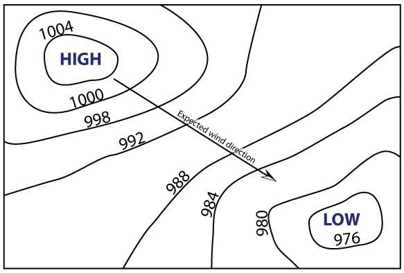
But, this is not the case due to the Coriolis effect which tends to make the wind directions more follow the isobar lines.
Coriolis Effect
The Coriolis effect is a fictional force that appears real in spinning objects like our planet Earth. In the diagram below, the first man rolls a ball to his friend. But by the time the ball makes the distance, the friend has moved. To both, it appears as though the ball was acted on by a constant turning force to make it veer off the original straight path. But there was no such force—it’s just an effect that we observe. Yet, it happened!
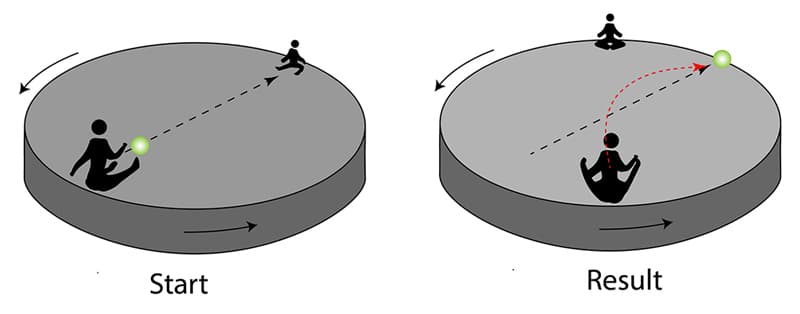
The Coriolis Effect
Due to the Coriolis effect, in the northern hemisphere, the spin of the Earth makes any air flowing south towards the equator turn west, while in the southern hemisphere, the spin of the Earth makes any air flowing north towards the equator similarly turn west. This is observed by areas of low pressure in the northern hemisphere turning counterclockwise, while areas of low pressure in the southern hemisphere turn clockwise. Essentially then, the winds follow the pressure lines angling in about 15 degrees in low-pressure zones and angling slightly outwards in high-pressure zones. This is depicted by the animation below.
The easiest way to remember the spin directions is by the saying: “An anticyclone spins anticlockwise in the antipodes.” (Australia and New Zealand were referred to as the antipodes in the olden days because they were directly opposite of inhabitants of the northern hemisphere.)
The Coriolis Effect on Weather Systems
Humidity and Moisture
The air holds water vapor in suspension. The amount of water it can hold depends on the temperature of the air and the pressure. For example, when the pressure is lowered by air rising, the air cannot hold as much water vapor and thus the water comes out of suspension, resulting in clouds and rain. In lows, the air is rising and thus the pressure decreases, resulting in clouds. In highs, the air is descending and thus increasing in pressure. Moisture is absorbed into the air, resulting in clear sunny days.
Fronts
Fronts are completely different from lows and highs. The term “front” was coined when the phenomenon was understood and documented during the time of World War I. In a war, when two armies clashed, a front line was established. It was then similarly named when describing the clashing of two opposing air masses. It is important to understand these as they generate significant changes in weather sometimes fast. By seeing these on a weather map prior to heading out, you will be able to understand what is about to come.
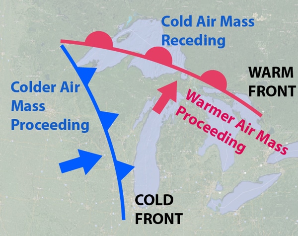
Cold Front
A moving cold mass of air clashing into a stationary warm mass of air creates a “cold front.” As the cold air strikes the warm, the warm air is immediately and violently lifted. As the warm air rises, water vapor is released. Thus, at the front line, you will see massive clouds and rain and a sudden change in temperature. Isobar lines will also make a directional change due to a sudden change in pressure, thus affecting the wind direction. On the other side of the front, the air is descending again and thus you can have good clear visibility after the passing of the front.
On a weather map, a cold front is represented as such:
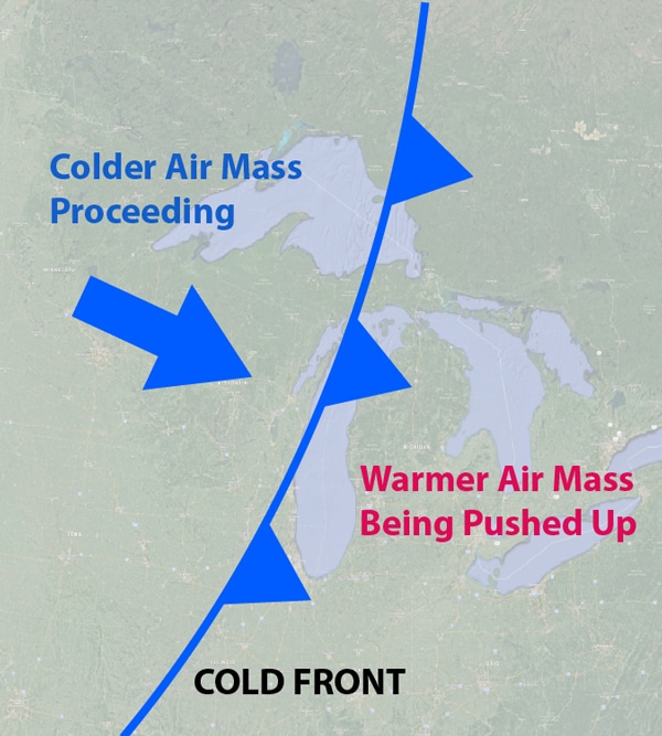
Cold Front
Backing and Veering Winds
A wind direction changing to come from a more counterclockwise direction than it is now is called a backing wind. A veering wind is a wind changing to come from a more clockwise direction. For example, say you are in the northern hemisphere and looking north. The wind is coming from the southwest (7:30 o’clock to you). A cold front passes and the winds have changed to the northwest (10:30 o’clock to you). The winds thus changed clockwise—they veered. This is typical in northern hemisphere cold front passages.
In southern hemisphere cold front passages, a typical wind change will be from northwest to southwest—backing.
A cross-sectional view of a cold front is below. As the front passes, you will notice a drop in temperature, and, in the northern hemisphere, you will notice a change in wind direction to come from a more clockwise direction.
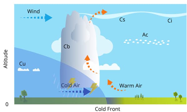
A Cold Front Cross Section
Cloud definitions are:
- Ci = Cirrus
- Cs = Cirrostratus
- Cb = Cumulonimbus
- Ac = Altocumulus
- Cu = Cumulus
Warm Front
A moving mass of warm air clashing with a colder mass of air will spawn a warm front and is represented on a weather map as such:
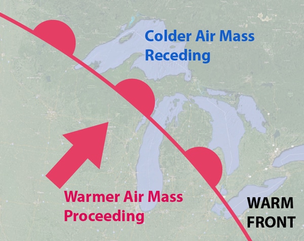
A Warm Front
A cross-sectional view of a warm front in the northern hemisphere is below. As the warm front passes, you will notice an increase in temperature and a change in wind direction to a more counterclockwise direction. The wind backed. In the southern hemisphere, the wind would veer.
As the warm front approaches, clouds will become lower and lower, and barometric pressure will decrease because of the rising air. At the frontal boundary, ground fog can be formed due to the temperature change. The worst visibility condition with a warm front will be as it passes and immediately afterward because of the moisture and possible rain in the air.
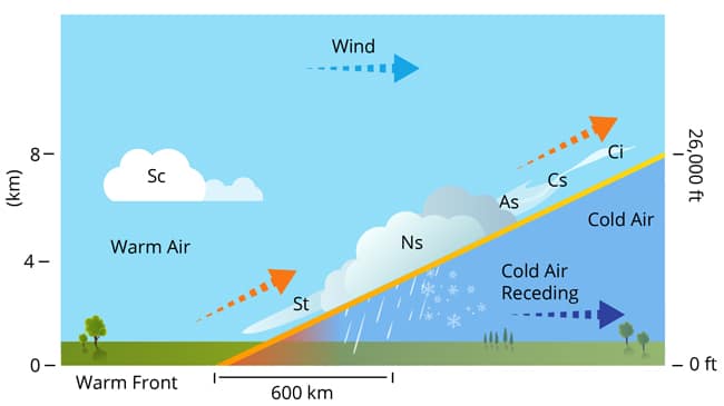
A Warm Front Cross Section
Cloud definitions are:
- Ci = Cirrus
- Cs = Cirrostratus
- Ns = Nimbostratus
- As = Altostratus
- Sc = StratoCumulus
- St = Stratus
Occluded Front
Occluded fronts are linked with areas of low pressure called depressions (more on these soon!). When a depression forms, there is usually a warm front and a faster-moving cold front. The (northern hemisphere) diagram below shows this. To the north of the warm front is the cool air that was in the area before the depression developed. When a cold front catches up to a warm front the result is called an occluded front. A wide variety of weather can be found along an occluded front, with thunderstorms possible, but usually, the occluded front passage is associated with a drying of the air mass. Occluded fronts can generate quite stormy weather as they pass over.
Occluded Front Forming
In the diagram below, the traveling warm air mass is replacing cooler air. At its leading edge is a warm front.
As the depression intensifies, the cold front catches up with the warm front (remember, a cold front moves faster than a warm front). This is shown below. The line where the two fronts meet is called an occluded front:
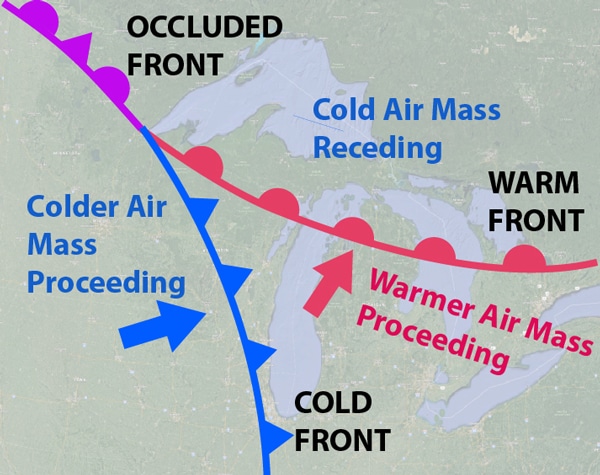
Occluded Front
A cross-section of an occluded front looks like this:
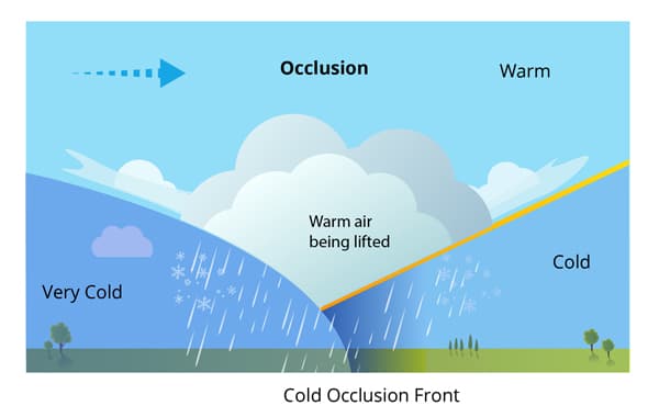
Occluded Front Cross Section
You can learn more in the Skipper Course....
Knowledge and theory for longer distances and overnight sailing in diverse conditions. The Skipper Course is a comprehensive online sailing course for beginner to intermediate sailors wanting to learn how to sail larger sailboats 26ft to 56ft. Or upgrade to the Skipper Course Bundle of online courses to also master maneuvering under power and docking!