This article is an excerpt from NauticEd’s Bareboat Charter Course, a comprehensive online course that equips you with all the necessary skills and knowledge to successfully charter a yacht. The Bareboat Charter course is part of the Bareboat Charter Master bundle of online courses, fully preparing you for near-coastal sailing and sailing charters.
You can learn to sail and improve your sailing with NauticEd, the international leader in sailing education.
The Nautical Chart on a Charter
Even though most sailboat charters are within island groups where the next landfall is typically within sight, every boat should be equipped with complete large-scale charts of the area. Charter companies are usually fairly good about providing a set of charts for the cruising area in which you’ll be operating. However, check the boat’s navigation station to be sure that paper charts are available; even if electronic charting is also provided.
 If you’re unfamiliar with charts then you should certainly take a course to become familiar with the use of charts and that is outside the scope of this clinic. The NauticEd Skipper course covers rudimentary navigation teachings. NauticEd also plans to release a navigation clinic in the near future. Check NauticEd’s list of clinics.
Consult the charts and plot courses for each destination you plan to visit. Note all possible hazards along the route, and avoid those areas. Be aware of currents, holding grounds, buoyage, and landmarks to use upon approach to anchor, moor, or dock. Make note of channel buoys, ranges, charted approach headings, depths, and land features that can help keep you on course. Consult tide tables and tidal current data if they are applicable to your waters. Note that tide is typically not a concern in the Mediterranean or Caribbean but currents are. You should have a very good idea of what to expect before you get there, but proceed slowly and under control; what you actually see can seem different or confusing once you’re on site.
I like to gather all pertinent charts for a given passage, arranged in the order in which they’ll be used. You may only require one chart for short passages, but keep them orderly if more will be needed. Mark your course lines, labeled with distance and course heading (in either true or magnetic, but always use the same system. I prefer to note chart headings in Magnetic since that is what the helmsperson steers (unless a significant deviation exists). If you don’t know the difference between a true and magnetic course, please learn it. There are sometimes significant differences. The NauticEd Skipper course explains this phenomenon.
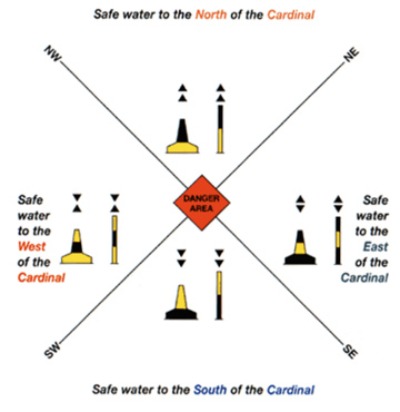
Cardinal Markers
The NauticEd Skipper Course explains day markers, lights, and beacons but a few extras are noted here because not all countries use the same. In particular, the cardinal system is not used in the United States but is in certain parts of the Caribbean and the rest of the world.
Cardinal markers tell you on which side there is safe passage around a hazard. For example, a North Cardinal marker will tell you to pass to the north of the marker for safe passage.
|
Cardinal Marker
|
Image
|
For safe passage
pass to the… |
Distinguishable by…
|
Picture
|
| North Cardinal |  |
North | The two arrows at the top point up towards the top the of the compass. Black support tube. | 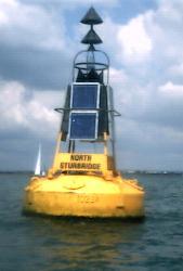 |
| South Cardinal |  |
South | The two arrows at the top point down towards the bottom of the compass. Yellow support tube. | 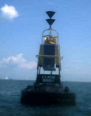 |
|
East Cardinal |
 |
East | The two arrows at the top point away from each other. Kind of looks like an egg (?) then remember by Easter Egg. |  |
| West Cardinal |  |
West | The two arrows at the top point towards each other. Notice that the sideways shape is kind of like a W. | 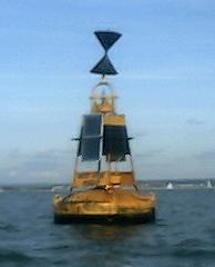 |
Or in summary…
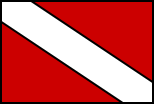
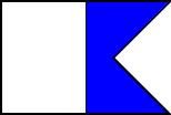
Another sign to watch out for
Americans are familiar with the recreational Diver Down warning flag as being red with a white strip however the rest of the world uses the alpha flag. Most country’s laws state that you must stay 300 feet or 100 meters away from a diver down flag.
| American diver flag | International Dive flag and alpha flag |
 |
 |
Cruising Guides
Certainly, you should take with you a cruising guide and many times the charter company will provide one for you. A cruising guide is a book of local resources and information about harbors, anchorages, etc. It has a wealth of information not only about safety but also about restaurants to dine in, reefs to dive, caves to explore, rocks to watch out for, recommended approaches to a bay, etc. You can usually buy these online and a simple search on the internet will reveal the exact guide you’re looking for. See below for the British Virgin Islands.

![]()
You can learn more in the Bareboat Charter Online Course....
The Bareboat Charter online sailing course is your go-to resource for planning an unforgettable sailing vacation. This comprehensive online course equips you with all the necessary skills and knowledge to successfully charter a yacht. Upgrade to the Bareboat Charter Master bundle of courses to fully prepare for near-coastal sailing and sailing charters.