
This article is an excerpt from NauticEd’s online Skipper Large Keelboats Course, a comprehensive online sailing course for beginner to intermediate sailors to learn how to sail large sailboats 26 ft (8m) and above. The Skipper Large Keelboats course is part of the Skipper Course Bundle of online courses, also teaching you how to master maneuvering under power and docking!
You can learn to sail and improve your sailing with NauticEd, the international leader in sailing education.
Navigation Units
Sailors are forever measuring stuff. This brings us to the subject of navigation units. As we all remember from the good ol’ school days, measurement is the process of comparing something with an established standard. How these various standards were initially derived often makes for interesting reading.
Most measurement units have evolved over time as technology advances. Many of the so-called English units of distance measurement are related to human body parts—for example, the foot. These units have associated seemingly random numbers for incremental measurements—12 inches per foot; 3 feet per yard; and 5,280 feet per statutory mile (which is different from a nautical mile). Be tolerant of these colorful units of measure; they have a rich history representing the evolution of humans and sailing.
Metric units were developed based on the distance between the Earth’s equator and the North Pole and the fact that the human hand has 10 fingers, which created the decimal system. Thus a major feature and advantage of the metric measurement units is that they are based on the decimal system; this makes for simple computations: 1000 millimeters (mm) in a meter (m); 100 centimeters (cm) in a meter; 1000 meters is a kilometer (km). A liter of water measures 10 cm by 10 cm by 10 cm and weighs 1 kilogram (kg) (on Earth); 1000 liters of water weighs 1000 kg which is 1 metric tonne. And just by universal coincidence, objects accelerate toward the Earth at 10 m/sec/sec (9.81 actually, but who’s counting?).
Air (weather) and water (seas) share many physical measurement units, including pressure, velocity, currents, temperature, directions, density, and cloudiness. These units evolved as measurement requirements became more critical and better instruments were invented. Some are highly technical terms while others are more familiar. Never be afraid to ask for the definition of words or concepts you do not understand.
Since we will use these terms throughout the course, we begin with a few common definitions. Keep in mind that many of today’s units of measure were in use long before the highly sophisticated scientific measurement tools that now exist. Also, keep in mind that measurements are always approximations.
- Statute mile—our common “road mile” is 5,280 feet. It is an arbitrary unit used only in the United States and Libya these days. It is about 1.6 km. You may know that the length of a foot was based on actual human feet—how accurate can that be?
- Nautical mile (nm)—6,076 feet, 1852 m (1.15 times the length of a statute mile). The cool thing about a nautical mile is that a nautical mile represents 1 minute of latitude. If you add up 60 minutes of latitude you make up 1 degree. Therefore, every degree of latitude represents 60 nautical miles going in the true north/south direction. The nautical mile is the standard unit of distance measurement for marine navigation today and is used on all marine charts.
- Lines of latitude are imaginary horizontal parallel lines that circle the Earth. Each line is equidistant in a vertical direction from the others at all points around the globe. Thus each circle going north or south away from the equator is smaller in diameter until you get to the North or South pole where the circle becomes a dot.
- Note: Longitude lines are not equidistant. They start at the poles and fan at equal angles from each other then come together at the opposing pole. Longitude lines are farthest from each other at the equator. Thus longitude lines cannot be used for distance measurement in the same manner as latitude lines. 1 minute of longitude in a horizontal direction is most definitely not 1 nautical mile. You might suppose they might be at the equator due to the Earth being a ball, but the Earth is not perfectly spherical.
- Knot—a measurement of speed. 1 knot is equivalent to one nautical mile per hour. It is approximately 1.15 times faster than 1 statute (road) mile per hour. In early times, the speed of the boat was determined by letting out a rope with a board attached to the end. The board would stop in the water while the boat carried on moving. The navigator would count how many equidistant knots slipped through the hand before a 28-second sand timer emptied. Can you figure out the distance between the knots?
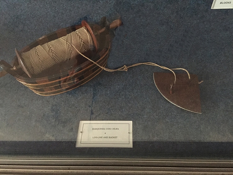
Original Knot Meter – on exhibit at Museu De Marinha, Lisbon
- 1 knot is about 2 km/hr (1.85 actually). This is a good conversion to remember; it makes for an easy conversion when thinking about wind speeds. For example, 50 km/hr is close to 25 knots (might want to throw a reef in the sail).
- The metric meter is 39.37 inches, that is, it is close enough to a yard (actually 3.37 inches longer than a yard).
- The kilometer is 1,000 meters or 3,280.8 feet or about 0.6 of a mile. 100 kilometers per hour is about 60 miles per hour. Did you know that it is about 10,000 kilometers from the equator to any one of the poles? That’s convenient!
- A meter is 1000 millimeters.
- A fathom is 6 feet. Thus 1 fathom is close enough to 2 meters. Fathoms are very often used on charts to express the water’s depth. We say often because many times it is not. Check the key on every chart before using it.
- Time: Universally measured in hours, minutes, and seconds. The time unit is now quite precisely measured using decaying radioactive materials. Chronometers (the common watch of today) were developed for marine navigation. One of the most famous chronometers, named H4, was developed by John Harrison in the 1700s. It is indeed a work of art. Harrison gave it to James Cook, who used it on his second and third circumnavigations in the 1770s. Cook praised it as being the future of navigation.
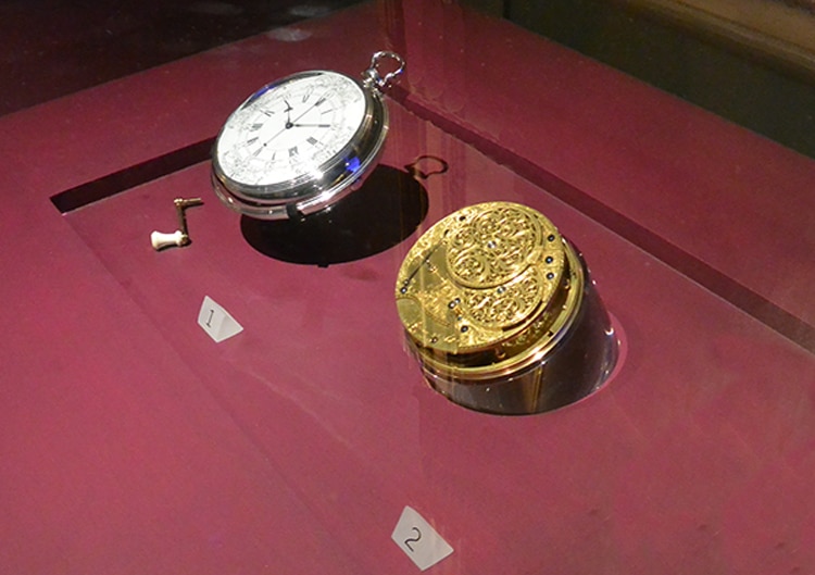
Harrison’s H4 on Display in the National Maritime Museum, Greenwich
- Furlong—220 yards. You’ll never use this so just forget it instantly, unless you’re a horse racing fan.
- Fortnight—14 days. Just for fun,100,000 furlongs per fortnight is about 37 miles per hour.
Anyway, in summary for the American palate, and not to trivialize, but a nautical mile is a bit more than a statutory mile; a meter is a bit more than a yard; a kilometer is a bit over half a nautical mile.
Wikipedia discusses the history of the Nautical Mile and other interesting facts.
Summary
You can learn more in the Skipper Course....
Knowledge and theory for longer distances and overnight sailing in diverse conditions. The Skipper Course is a comprehensive online sailing course for beginner to intermediate sailors wanting to learn how to sail larger sailboats 26ft to 56ft. Or upgrade to the Skipper Course Bundle of online courses to also master maneuvering under power and docking!