
This article is an excerpt from NauticEd’s online Skipper Large Keelboats Course, a comprehensive online sailing course for beginner to intermediate sailors to learn how to sail large sailboats 26 ft (8m) and above. The Skipper Large Keelboats course is part of the Skipper Course Bundle of online courses, also teaching you how to master maneuvering under power and docking!
You can learn to sail and improve your sailing with NauticEd, the international leader in sailing education.
Latitude and Longitude
The latitude and longitude coordinate system is the key navigational concept for sailing. It is the mariner’s coordinate system.
To express latitude and longitude, we use units of measurement called degrees and fractions of degrees. Recall from your math class that there are 360 degrees in a circle. Why? It comes from the original thought that the Earth took 360 days to rotate around the sun. Pity it did not take 100 days—this would have made school geometry much easier; but that may have created other evolutionary complications, so just go with 360 and be thankful.
Each degree is subdivided into 60 minutes of angle and each minute is subdivided into 60 seconds of angle. You will note similarities with the way we tell time.
1 circle = 360 degrees
1 degree = 60 minutes (of angle/distance, not time)
1 minute = 60 seconds (of angle/distance, not time)
How many seconds of angle are there in 1 circle?
Typically, instead of expressing degrees, minutes, and seconds, a coordinate is expressed in degrees and minutes with the minutes expressed as a decimal point. For example, 17 degrees 10 minutes 30 seconds is more often expressed as 17 degrees 10.5 minutes.
The North and South Pole
If you took a stick and jammed it down through the Earth about the axis where it spins, those points where it enters and exits are the poles. They are fixed in space on our planet. Have been and always will be. Thus, the cartographers were wise to choose these points as the basis for setting up the planetary coordinate system.
Latitude
Lines of latitude are man-made lines and can be thought of as circles going around the Earth that are parallel to the equator. Thus the circles get smaller in circumference as they near each pole. By their nature then, to jump directly north or south from one latitude circle anywhere on the planet to the next latitude circle is the same distance.
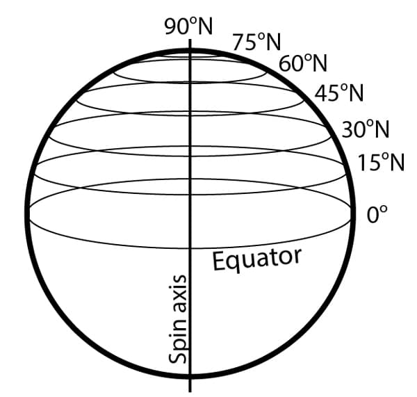
Lines of Latitude
The one non-man-made latitude line is the equator. This is universally ordained and defined from the axis of spin. Cartographers set the equator to be 0 degrees of latitude and since the poles are 90 degrees around the sphere, the poles became 90 degrees North of the equator and 90 degrees south of the equator.
A cool thing about latitude is that it defines the distance unit of a nautical mile on our planet. Ninety degrees of latitude on the surface of Earth is equivalent to the distance from the equator to the North or South Pole. One degree of latitude then is defined as 1/90th of the surface distance from the equator to the North or South Pole. Since degrees are divided into 60 minutes of angle as above, it was cleverly decided that 1 nautical mile should equal 1 minute of latitude. This is by definition not by coincidence. How many nautical miles are there from the equator to the North Pole then? 90 x 60 = 5400.
Remember this:
- 1 minute of latitude = 1 nautical mile
- 1 degree of latitude = 60 nautical miles
The easy way to remember which way latitude goes is that the “lat” in latitude rhymes with “flat,” which is a horizontal line going around the Earth.
Longitude
Lines of longitude may be thought of as lines running around the surface of the Earth starting at the North Pole, going directly to the South Pole, and back up the other side of the planet to the North Pole again. Thus, these lines are really circles.
The lines are obviously not parallel, but all have the same circumference. These imaginary lines are lines of longitude or meridians. Since they converge at the poles, their separation varies from the equator to the pole. Thus, it is imperative to understand that distance between lines of longitude cannot be used for any form of distance measuring.
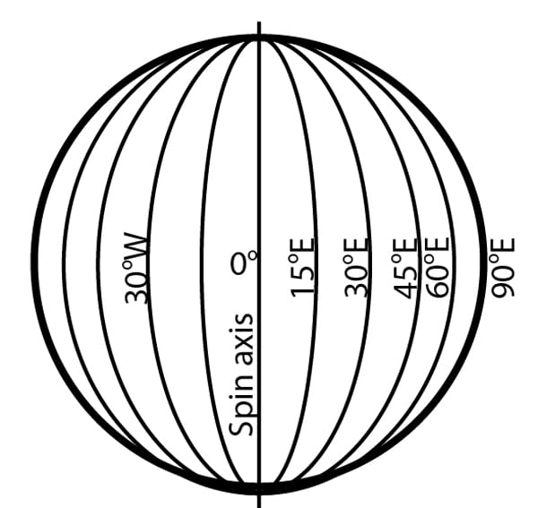
Lines of Longitude
Great Circles
A “great circle” is a circle on the Earth’s surface whose plane passes through the center of the Earth. They are like longitude except they do not have to pass through the two poles. The shortest distance between two points on the Earth’s surface is an arc that lies on a great circle. This is why when a plane flies from Chicago to Narita, Japan, or New York to New Delhi, it flies close to the North Pole instead of a straight line on a flat world map. The North Pole route lies on a great circle and represents the shortest distance for the plane to fly. All longitude lines are “great circles” since their plane passes through the center of the Earth. Latitude lines do not. You will use this information if you ever start sailing long distances.
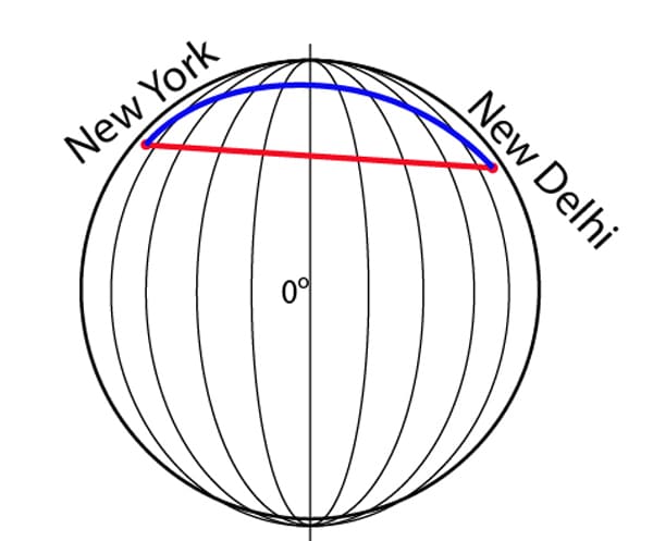
Traveling on a Great Circle Line
Since the Earth is round, we must decide which of the infinite number of lines of longitude should be the beginning line; the zero-degree longitude line. Years ago, the British decided that the line of longitude running through Greenwich, England would be the beginning, and so they named it the prime meridian.
As we sail around the world, in either easterly or westerly direction, we can identify our location by the number of degrees and minutes that we are away from this prime meridian. For example, longitude 65° 35.8Í´ W means we are west of the prime meridian by 65 degrees and 35.8 minutes. Similarly, longitude 65° 35.8Í´ E means we are east of the prime meridian by 65 degrees 35.8 minutes.
So there you have it—given longitude (stated in degrees east or west) and latitude (stated in degrees north or south) you can locate any point on the surface of the Earth. That point is unique; no other point on the surface of the Earth has those coordinates.
Understanding this pair of numbers is the key to naval navigation.
The following shows latitude and longitude laid out on a sphere (the Earth) with several key world cities placed. In this instance, it is noon in London, 7:00 a.m. in New York, and on the other side of the planet, say Auckland, New Zealand, (36 degrees 52 minutes south/174 degrees 45 minutes east), it is midnight.
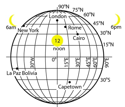
Latitude and Longitude on Earth
What’s cool about longitude is that it helps us with time. A day is defined by a full rotation through 360 degrees of our planet. This takes place in exactly 24 hours. Our time zones then (disregarding political intervention) follow every 360/24 = 15 degrees of longitude. Thus, if it is noon where you are and it is 6:00 a.m. where I am, then I must be 6 x 15 = 90 degrees of longitude to the west of you = 1/4 of the way around the planet.
As an example, say I knew it was 6:00 p.m. in London but the sun just apexed overhead where I am, then I know my longitude will be 90 degrees west.
An amazing, clear, and fun book to read on the subject is Longitude, by Dava Sobel. It describes how sailors came to accurately determine their longitude. It wasn’t until the King of England offered a £10,000 reward for the first person to be able to accurately position a vessel within 1/2 degree in the early 1700s that the challenge really got taken up. The answer wasn’t discovered until the 1760s.
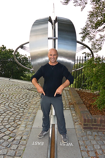
After you have read this book, take a trip to Greenwich, England. It’s a 20-minute train ride from London and there you can see the zero-degree meridian (the prime meridian) line for yourself. While you are there visit the National Maritime Museum, and a quick sampling of the local pubs around Greenwich doesn’t hurt either.
You can learn more in the Skipper Course....
Knowledge and theory for longer distances and overnight sailing in diverse conditions. The Skipper Course is a comprehensive online sailing course for beginner to intermediate sailors wanting to learn how to sail larger sailboats 26ft to 56ft. Or upgrade to the Skipper Course Bundle of online courses to also master maneuvering under power and docking!