This article is an excerpt from NauticEd’s online Skipper Large Keelboats Course, a comprehensive online sailing course for beginner to intermediate sailors to learn how to sail large sailboats 26 ft (8m) and above. The Skipper Large Keelboats course is part of the Skipper Course Bundle of online courses, also teaching you how to master maneuvering under power and docking!
You can learn to sail and improve your sailing with NauticEd, the international leader in sailing education.
Always familiarize yourself with any chart before using it for navigation and plotting of positions; there are significant differences between charts that could lead to mistakes. Always check:
Scale: Be certain you’ve selected the right chart for your purpose. There may be another sub-chart that shows more detail.
The units in which depth soundings are measured — also vary on different charts. Soundings can be in fathoms, meters, or feet. Be sure, for example, that when you’re reading the number “5,” it doesn’t refer to 5 feet instead of 5 meters.
Depth contours and colors: Color charts and electronic charts show shallow depth by color following a contour.
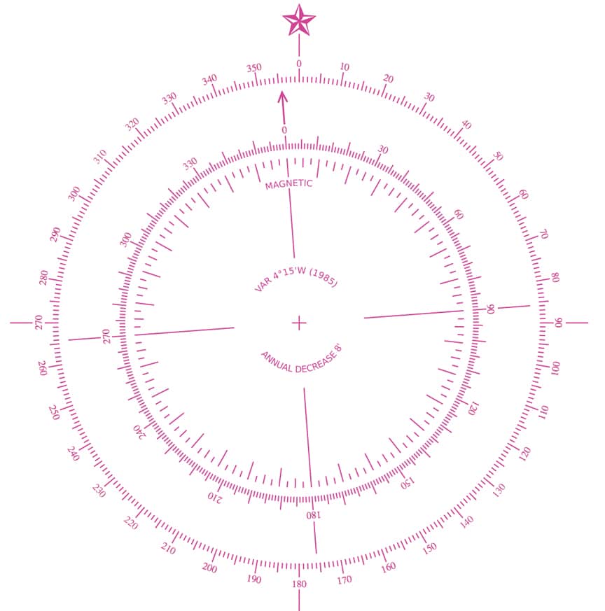
The local Variation. This is the difference between Magnetic North and True North. Courses calculated need to take this into account. More on this later.
Increments of the latitude scale. The scale at the east and west edges is that of latitude, used to measure distance on a nautical chart. One minute of latitude = one nautical mile of distance. Be sure to understand what hash marks represent one minute on the latitude scale. The image below illustrates a latitude scale on which each small hash mark represents two minutes of latitude.
Latitude Scale Lines
The compass rose, shown below, is an important feature of nautical charts. It is usually comprised of two concentric rings; the outer circle represents geographic True North, whereas the inner ring depicts magnetic directions that reflect local Variation and corresponds more closely with readings of the vessel’s compasses. The Variation is usually given in the center of the rose.
A Typical Compass Rose
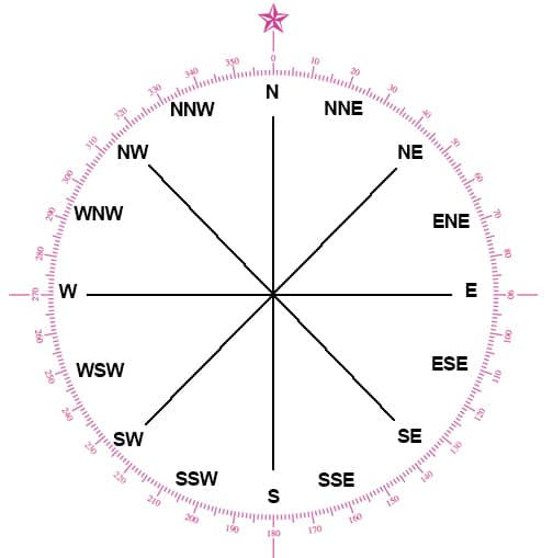
Directions
Directions are given as zero through 359 degrees in a clockwise direction. (360 = 0) relative to the North Pole.
North (N) is 0 deg (= 360 deg)
East (E) is 90 deg
South (S) is 180 deg
West (W) is 270 deg
There are various combinations of N, S, E, and W to divide the directions as shown. For example, NNE is 22.5 degrees. When someone is quoting a direction they will follow the number by T (True) or M (Magnetic) when in writing. When spoken use “True” and “Magnetic” sounded out—not “T” or “M”. Details, but we’re saving you from VHF embarrassment here.
See the compass rose below and also note how the designations of NSEW are listed. Note that it is, for example, NNE not NEN, and WSW, not WWS. The order of the letters is important and should be followed as such below.
NSEW Direction Combinations
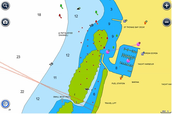
This chart below from Navionics of Spanish Town in the British Virgin Islands shows the shallow depths by colored contour lines. Green is usually represented by the Drying Depth, which means the area is above water at low tide. Blue often represents shallow. Light blue is less shallow. The depth of the contour line will be shown on the contour line; often in a different font than the font marking the actual depth.
Navionics Chart of Spanish Town, BVI
Depths
Many charts will have a “Source Data” table listing areas of the chart and how the depth data was obtained. Surprisingly, you might still find charts where depth was obtained by lead lines and not by the far more accurate electronic depth sounders. The source and date of when the data was obtained are thus very important.
You can learn more in the Skipper Course....
Knowledge and theory for longer distances and overnight sailing in diverse conditions. The Skipper Course is a comprehensive online sailing course for beginner to intermediate sailors wanting to learn how to sail larger sailboats 26ft to 56ft. Or upgrade to the Skipper Course Bundle of online courses to also master maneuvering under power and docking!
Authors: Grant Headifen, NauticEd Global Director of Education
NauticEd is a fully recognized education and certification platform for sailing students combining online and on-the-water real instruction (and now VR). NauticEd offers +24 online courses, a free sailor's toolkit that includes 2 free courses, and six ranks of certification – all integrated into NauticEd’s proprietary platform. The USCG and NASBLA recognize NauticEd as having met the established American National Standards.