This article is an excerpt from NauticEd’s online Skipper Large Keelboats Course, a comprehensive online sailing course for beginner to intermediate sailors to learn how to sail large sailboats 26 ft (8m) and above. The Skipper Large Keelboats course is part of the Skipper Course Bundle of online courses, also teaching you how to master maneuvering under power and docking!
You can learn to sail and improve your sailing with NauticEd, the international leader in sailing education.
Electronic Communications
A ThoughtImagine if humans had 16 fingers instead of 10. We’d all be able to grasp hexadecimal code a lot easier. 10 would be 16. Just sayin! Maybe computers would have been invented earlier! Why is 1 second, one second long? If it had been 24/16 longer there could have been 16 (10) hours in a day? And why not 100 degrees in a circle? It goes on … |
Morse code uses a long blip and a short blip. Combinations of these blips represent a letter. A fast human Morse coder could send ten letters in a few seconds but the accuracy depended also on the human receiver’s ability to decode the message equally as quickly.
Nowadays, gigabytes of data can be sent in a second as a digital signal. It is all a complete Wow! And we’ve seen this invention of technology, including all the working satellites launched into orbit in our lifetimes. Signals travel and are coded and decoded at the speed of light.
All these signals benefit our ability to communicate with each other. AND the field of electronic communication continues to explode. Knowing the importance of knowledge and data, sailors have embraced technology. Even the laggards and Luddites carry an iPhone in their pocket to communicate with their grandchildren via video over 5G or to retrieve tidal information about a port.
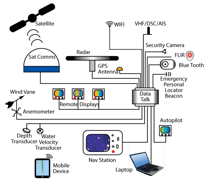
Most larger sailboats these days make use of most of the systems in this diagram.
Data Communications
Compare this to what Captain James Cook would have carried on the Endeavor when he set out to measure and observe the transit of Venus across the sun in 1769 from the island of Tahiti.
Although telecommunications technology is improving quickly, people at sea need to know how to use many specific maritime communication methods including:
- Communicate with other ships and shore
- Receive real-time weather information
- Send or receive distress alerts in an emergency to or from rescue coordination centers ashore and nearby ships
- Receive navigation information
- Send and receive traffic information
So given all the above, the following is a discussion of what you are expected to know when operating your vessel.
VHF Radios
VHF (Very High Frequency) radios are a primary source of radio communications between vessels and shore installations. More importantly, crucial in fact, VHF radios are a primary source of communication during an emergency. Most maritime safety organizations monitor VHF radio signals – specifically channel 16, the international distress, safety, and calling channel.
Operating VHF radios is easy, but there are protocols to follow. One thing to keep in mind is that the sender and the receiver cannot talk at the same time. This is often difficult to remember in an emergency. Transmissions should be kept short and cover only vital issues.
If you put out a distress signal on channel 16, the chances of it being heard by someone who can rescue you is almost 100 percent. The “almost” lies in the distance VHF signals can travel and land mass obstructions in the way.
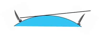
VHF Signal
VHF is essentially a line-of-sight system since radio waves don’t bend very much to follow the curvature of the Earth. Sometimes the signal can reflect and refract around land masses but mostly if there is a land mass in the way you cannot expect your signal to get through. For most reliable VHF communication, the VHF antenna must “see” the antenna of a distant station.
Therefore, antenna height is more important in determining the range than radio wattage. The effective useful range of a VHF radio is 20 to 25 miles for ship-to-shore and 10 to 15 miles for ship-to-ship. The distance a VHF signal can reach between ship and shore installations is usually a bit further since the ground-based antenna is higher.
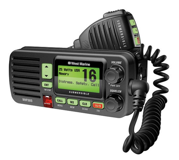
Fixed-Mount VHF Radios
Fixed-mount units are just that—they are permanently fixed into your boat and are usually high wattage, up to 25 watts. They gain their power from the house battery system.
VHF Radio
Handheld VHF Radios
VHF handhelds also offer many of the same features found on fixed-mount units. They offer portability in the same way a cordless phone allows more mobility at home. A handheld radio may be just what you need for use in a dinghy, or small boat without electrical systems, or as an emergency backup for your boat’s radio. Handhelds have a maximum output of six watts. Due to their short antennas, they have a limited range of five miles.
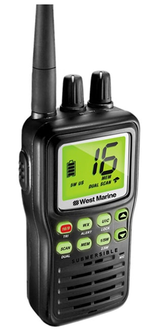
Handheld VHF
You can achieve a significant increase in range by connecting an external antenna or using a telescoping antenna mounted to the handheld radio. Battery life varies with the size of the battery pack. Many models have optional battery packs with longer operating times, greater transmitting power, or both. Some have battery-saver circuits that turn off the receiver to save power. The battery life of a handheld can be increased by switching from full transmit power to one watt of transmit power.
If you have handheld VHF radios on board, make sure you also have a way to charge them.
Check out a handheld VHF/DSC radio product review video from West Marine.
Handheld VHR video
Channel 16
Channel 16 is the most important VHF channel for sailors. It is essential for all emergencies. The United States Coast Guard and most other country’s coast guard systems monitor channel 16, 24 hours a day, 7 days per week.
Channel 16 is designated as the single channel to be constantly used by all vessels at sea. This channel is a sailor’s best link for communicating problems with other vessels or ground-based stations.
You can find the proper procedure for using your VHF—Channel 16—radio in an emergency in Chapter 11.
General Calls to Other Ships or to Shore
You can refer to the Wikipedia marine VHF Channels website for a table of VHF Channels for the UK, USA, Canada, Australia, New Zealand, and Finland.
Each channel has a specific use. Note carefully the channels you as a recreational non-commercial boater can use to communicate.
Each channel operates on a different VHF frequency. Here is a summary for the USA:
- Channel 09—Boater Calling. Commercial and Non-Commercial.
- Channel 16—International Distress, Safety, and Calling. Any ships that are required to carry a VHF radio. Global Coast Guards and most coast stations maintain a listening watch on this channel.
- Channel 68—Non-Commercial traffic
- Channel 69—Non-Commercial traffic
- Channel 71—Non-Commercial traffic
- Channel 72 —Non-Commercial (Inter-ship only)
- Channel 78A—Non-Commercial traffic
All others are for port operations, commercial traffic government, and the like. They should not be used by recreational boaters. Note in particular that Channel 70 is for DSC distress signals. No voice is allowed on Channel 70. Sometimes you’ll see an A and B switch. A is typically used in the USA; B is used outside the USA (sometimes labeled as “international”).
Procedure for Hailing a Ship by Radio
You may use channel 16 to hail a ship or shore station, but if you do so, you must, must be brief! We recommend this same procedure be used over channel 9 if channel 9 is used as a calling channel.
A hailing example:
Blue Duck: “Mary Jane, this is Blue Duck” (the name of the vessel being called may be said 2 or 3 times if conditions warrant).
Mary Jane: “Blue Duck, this is Mary Jane. Reply 68” (or some other proper working channel).
Blue Duck: “68” or “Roger”.
Both switch to channel 68 (as an example). Have the conversation. End each turn with “over.” End the conversation with your station name and “out.”
Operator’s License
Some countries in the Mediterranean require that you have a VHF operator’s license before entering their waters. If chartering a yacht, the charter company is required to ensure you have the same before heading out.
DSC – Digital Selective Calling
View a quick introductory video on DSC:
DSC Introductory Video
Digital Selective Calling, or DSC, is particularly excellent for distress signals. When the red distress button is activated, it automatically broadcasts an encoded digital distress call that will be picked up by all nearby vessels equipped with DSC. The designated VHF channel for DSC transmissions is channel 70. Therefore, you cannot use channel 70 for any reason other than DSC calls. The radio then automatically switches to channel 16 to allow voice communication. Since DSC uses VHF, it also is limited in range. The advantage is that it can send digital data that can be received much clearer than a garbled voice. The data sent in an emergency situation will include a distress signal, the GPS location, the vessel information, and much like pre-formatted texts, conditions like “sinking” can be included.
If the radio is interfaced with GPS, it will also automatically broadcast the distressed vessel’s position. All DSC radios have an input connector protocol that allows GPS data input. If you have a GPS and a DSC radio, CONNECT THEM. Many DSC radios now include GPS as a built-in feature.
To use DSC, you must obtain a MMSI (Maritime Mobile Service Identity) number. You may do so free of charge at this web address: http://www.boatus.com/mmsi.
Note that DSC signals on VHF radios are still limited to VHF ranges. But through the network of DSC-listening vessels in the area, your distress is likely to be heard. For this reason, if your vessel is fitted with DSC you are required to have the device on when you are on board.
Here is another video that talks more in-depth about DSC radios.
DSC Video
Telephones
Maritime Rescue centers do not recommend relying on cellular phones as a means of communication during an emergency.
Ordinary cell phones do work well so long as the unit is in approximately line of sight of a receiving tower.
In regards to using the phone for emergencies; first, who are you going to call, and do you have their phone number? You can’t speak to the helicopter to coordinate the rescue via cell phone. The best you might manage is to call your mother-in-law (why she is on speed dial we don’t know) and tell her to call the authorities. Then you’re expecting her to write down a latitude and longitude number? Is her daughter on board? Does she really like you? Is this her chance?
Bottom line: Make sure your vessel has an up-to-date VHF unit with DSC.
EPIRB
Pronounced “e-purb,” an EPIRB is an acronym for Emergency Position Indicating Radio Beacon and is an emergency communication device that, when activated, continuously emits signals to be picked up by satellites that then can direct rescue efforts. They float and are practically indestructible. A Category I EPIRB that gets wet will automatically activate. A Category II EPIRB requires manual activation. If a vessel begins to sink, the now-submerged mounting device for the EPIRB will automatically release the EPIRB, allowing it to float.
=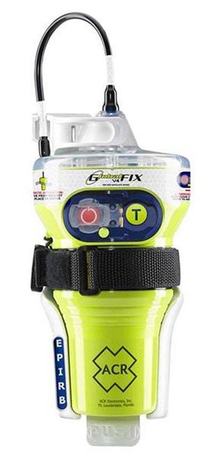
EPIRB
As soon as an EPIRB is activated, its signal is received by satellites, passing airplanes and ships, and VHF towers within the VHF range. It is then broadcast to other ground stations and eventually after several microseconds to search and rescue authorities. Old EPIRBs relied on satellites triangulating the signal to obtain a location within a little more than a mile (2 kilometers). Newer EPIRBs broadcast GPS signals with a unique device number that is specifically registered to a vessel. In this manner, SAR (Search and Rescue authorities) have valuable information about the vessel and its accurate position immediately.
You are well advised to ensure your vessel has a Category I EPIRB. It could save your life.
As with most electronic gear, the costs have dropped while their performance and reliability have improved. For sure, you are now no longer alone on the big oceans.
Personal Overboard Locator Beacon (POLB)
Personal overboard locator beacons are electronic tether devices worn by each crew member, dog, cat, or other items you care to save. When a POLB goes overboard, it starts transponding and sending alerts. The frequencies and alerts depend on the type of system. Some go via satellite, some via VHF/DSC.
POLB
AIS
The Automatic Identification System (AIS) is an automated tracking system used on ships and by Vessel Traffic Services (VTS) for identifying, locating, and tracking vessels. With an AIS unit on board, you can see if a ship is a threat to your current course and position. AIS information supplements marine radar, which continues to be the primary method of electronic collision avoidance for water transport. Information provided by AIS equipment, such as identification, position, course, speed (or at anchor), closest point of approach (CPA—how close will the vessel get to my vessel?) and time to the closest point of approach (TCPA—when will the CPA take place?) can be displayed on a screen for analysis by the watch person.
AIS operates at 161.975 MHz on the VHF band. Currently only ships over 300 gross tonnage or passenger ships of any size are required to broadcast AIS information about their vessel. However, some recreational vessels now have opted to broadcast AIS for safety reasons; but many don’t. Thus, you’re not going to get an accurate picture of all traffic with AIS. As a result, AIS should not be considered an automatic collision avoidance system but rather a way to gauge the risk of collision. Keep in mind that if you’re transmitting an AIS signal, then large ships have a better chance of seeing you, even if you are way out at sea, which creates some peace of mind.
In 2007, a new class B standard of AIS was introduced that enabled a new generation of low-cost AIS transducers and thus triggered recreational mariners to invest in the AIS technology for their vessels. A third class is a receive-only AIS, meaning you can see information about them, but they can’t see you.
The transmitting AIS units (A and B) require a GPS transponder unit to collect your GPS position in order to transmit.
The video below is an excellent summary of AIS technology in action.
AIS
Radar
Radar stands for Radio Direction And Ranging. The acronym was coined by the U.S. Navy in the 1940s, just prior to the U.S. entering World War II.
Radar Animation
While the electronics of radar are pretty complicated the principle is quite simple. When you send out a signal and measure the time (t) for an echo to come back, the distance (D) to the object reflecting the signal is found by:
D= c x t/2
Where c = the speed of the signal. And in the case of radio waves, c = the speed of light = 299,792,458 m/sec.
It’s pretty amazing that we have electronics that can measure time differences at those kinds of speeds. For example, if an object is 1 nautical mile (1852 m) away, the time for the reflection to come back is:
t= 2 x D/c
= 2 x 1852 / 299,792,458
= 12 microseconds
= 12 millionths of 1 second
= wow!
But even better than that, the electronics can distinguish things that are 10 meters apart from the time differential. Double wow!
With radar, you can “see” weather systems approaching, land masses, and other vessels even if you cannot see them. Just a note, however: the Rules for Prevention of Collision at Sea DO NOT allow for the replacement of a visual lookout with radar (or AIS for that matter).
Even if your vessel does not have radar, you can utilize weather radar information broadcast on the Internet with your handheld phone or tablet. If you see dark clouds, you are well advised to pull out your device and view the local weather radar.
You can learn more in the Skipper Course....
Knowledge and theory for longer distances and overnight sailing in diverse conditions. The Skipper Course is a comprehensive online sailing course for beginner to intermediate sailors wanting to learn how to sail larger sailboats 26ft to 56ft. Or upgrade to the Skipper Course Bundle of online courses to also master maneuvering under power and docking!