
This article is an excerpt from NauticEd’s online Skipper Large Keelboats Course, a comprehensive online sailing course for beginner to intermediate sailors to learn how to sail large sailboats 26 ft (8m) and above. The Skipper Large Keelboats course is part of the Skipper Course Bundle of online courses, also teaching you how to master maneuvering under power and docking!
You can learn to sail and improve your sailing with NauticEd, the international leader in sailing education.
Chart Symbols
Studying a harbor layout does very little good without understanding the symbols and what they signify. It pays to learn the symbols found on nautical charts.
These are widely available in an array of nautical books and on the reverse side of many charts. The most readily available and always up-to-date source is found in your maritime government; in the USA it is NOAA—Office of Coast Survey. This PDF downloadable book contains globally used symbols. The book is called
Chart No. 1: Symbols, Abbreviations, and Terms.
Download the Chart 1 on the Internet for free by going to:
Or get a spiral-bound hard copy on Amazon for $12 or so.
Amazon – Chart 1
An example of the pages inside chart 1 is shown here. This is an excerpt from Section K.
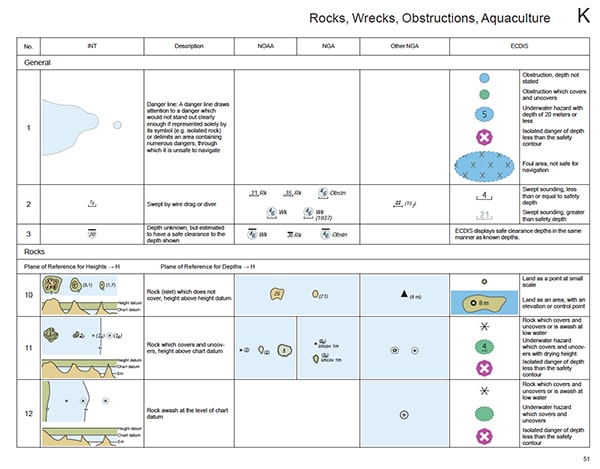
Chart 1 Section K Excerpt
View this animation, which takes you through some of the symbols and elements of a chart.
Chart Familiarization Animation
Chart 1
It is imperative that you not gloss over this section as you read, so we advise that you really gain access to Chart 1 now. Below we will take you through some of the more common symbols and give you a brief view into Chart 1.
Now look up the symbols on the following pages of Chart 1:
- C 13. Learn the heights of land.
- Not sure why Bridges are in Section D under Cultural Features—but they are. Check those out.
- F 14. Jetties and Piers.
- Peruse Sections H, I, and J to learn currents, depths, and bottom types.
- Pay particular attention to Section K—Rocks, Wrecks, and Obstructions.
- View L 30.1 to see the submarine cable shown in the animation above.
- View M 10 through 18, then figure out the two examples of routing measures shown for paper and electronic charts.
- Study N 2 and N 12.
- Get a feel for Section P—Lights and Section Q—Buoys and Beacons. We’ll go through these later. Study Q 130 in particular.
- Peruse R, S, and T.
- See that there is a list of abbreviations and an index at the end.
- Finish by viewing the Appendix.
Another Source of Information on Symbols
Admiralty Chart 5011
Admiralty Chart NP5011 is the equivalent to the U.S. Chart 1 and is published by the UK Hydrographic Office.
You can learn more in the Skipper Course....
Knowledge and theory for longer distances and overnight sailing in diverse conditions. The Skipper Course is a comprehensive online sailing course for beginner to intermediate sailors wanting to learn how to sail larger sailboats 26ft to 56ft. Or upgrade to the Skipper Course Bundle of online courses to also master maneuvering under power and docking!