
This article is an excerpt from NauticEd’s online Skipper Large Keelboats Course, a comprehensive online sailing course for beginner to intermediate sailors to learn how to sail large sailboats 26 ft (8m) and above. The Skipper Large Keelboats course is part of the Skipper Course Bundle of online courses, also teaching you how to master maneuvering under power and docking!
You can learn to sail and improve your sailing with NauticEd, the international leader in sailing education.
Aids To Navigation (ATONS)
Aids to Navigation include buoys, lights, lighthouses, and markers, among others.
Lateral Mark
A lateral buoy, also called a lateral post or lateral mark, is defined by the International Association of Lighthouse Authorities (IALA) as a sea mark used in maritime pilotage to indicate the edge of a channel. The red and green shapes are called either a Nun or a Can depending on their color and part of the world they are used.
Each mark indicates the edge of the safe water channel in terms of port (left-hand) or starboard (right-hand).
A vessel heading into a harbor and wishing to keep in the main channel should:
- keep port marks to its port (left) side, and
- keep starboard marks to its starboard (right) side
Obviously, a vessel heading out of a harbor should proceed opposite to the above.
For the aid of memory, it is prudent to learn only what you should do when entering a harbor. Then you just apply the opposite when exiting. The last thing you want to do is to get flustered at night and try to remember which is which. Just learn one of the entering-harbor mnemonics presented below.
Sometimes lateral marks are not necessarily used solely in a harbor. They are also used in a river or coastal waterway. Logically for rivers, the upstream direction is treated the same as entering a harbor. For coastal waterways, you need to check the chart as to determine which way is considered “returning.”
The International Association of Marine Aids to Navigation and Lighthouse Authorities (IALA) has adopted two systems, IALA-A and IALA-B, whereby the colors are swapped.
The USA and all the Americas, the Caribbean, North Korea, the Philippines, and Japan use the IALA-B system. The rest of the world uses IALA-A. (Who could have guessed?)
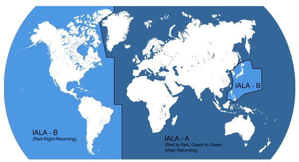
IALA Regions
The following is a guide to understanding the Aids to Navigation in the IALA-B system. If you are under IALA-A then just learn the opposite colors (colors).
Essentially, for IALA-A and IALA-B, the colors are swapped (but not the shapes) for entrances into harbors. The reason is said to be that the Americans during the War for Independence wanted to confuse the British ships and so swapped the colors.
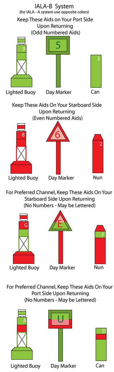
You absolutely must learn the difference between IALA-A and IALA-B and where they are used—particularly if you are chartering in various parts of the world. But don’t worry, they are easy. All you have to do is remember the mnemonic “Red, Right, Returning” under the IALA-B system. That’s it! So, for example, under IALA-B, when you are returning from the sea into the channel (or going upstream in a river) keep the red markers on your right. In the case of the preferred channel, take notice of whatever color is on top. That is, if red is on top, keep the marker on your right for the preferred channel. Red Right Returning! Right?
If you live under the IALA-A system then just remember Red-to-Red and Green-to-Green when returning. So when you are returning from sea into the channel (or going upstream in a river), keep the green markers facing your green light and the red markers facing your red light. Our advice is to only learn one of these that suits you best. Then just apply the opposite logic/mnemonic when visiting a different IALA system.
Shapes of Lateral Marks
Lateral marks have shapes as shown below. A mnemonic to remember the shapes and colors for IALA-B that is commonly used is “even nuns blush red.” Meaning nuns have even numbers and are the red lateral mark. Nuns have a cone shape or triangle shape pointing up. Consequently, under IALA-B the green lateral mark is called a can and is numbered with odd numbers. The cans have a square top.
Again, learn what you are used to in your local area and swap colors but not shapes when you travel to a different IALA region. Use the below to determine what color and shape a return port lateral mark is in IALA-A and IALA-B.
Lateral Marks
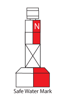
Safe Water Marks
One type of safe water mark is shown below, but there are other shapes as well—they are usually characterized by white and red vertical marks. They are not numbered but may be lettered. The letters have no significance other than individual identification.
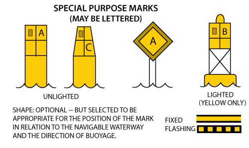
Special Purpose Marks
Special purpose marks are yellow and are used to mark such areas as anchorages, dredging and survey operations, and fishnet areas. They vary in shape from cans to balls to day boards.
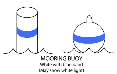
Mooring Buoys
Mooring buoys are white with a blue stripe. If they are lighted, they exhibit a fixed white light.
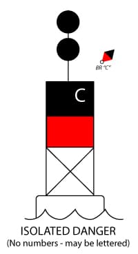
Isolated Danger
Isolated danger marks bear a black strip on top of a red strip. They may be lettered for individual identification. The chart marks show “BR” (for black red) followed by the letter designation if it exists.
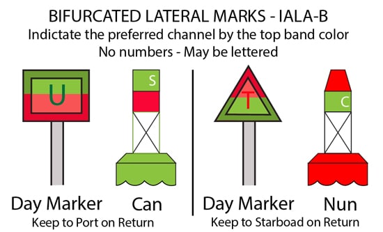
Bifurcated Lateral Mark
In the case where a channel may split, the preferred channel has green and red horizontal bands. To follow the preferred channel, ignore the color of the lower band. For example, if red is the band on top, then pretend that the entire lateral mark is red. If returning from sea under IALA-B you would keep it to right. Right?
Putting it all Together
The diagram below is a simple example of how you might navigate a channel in an IALA-B area.
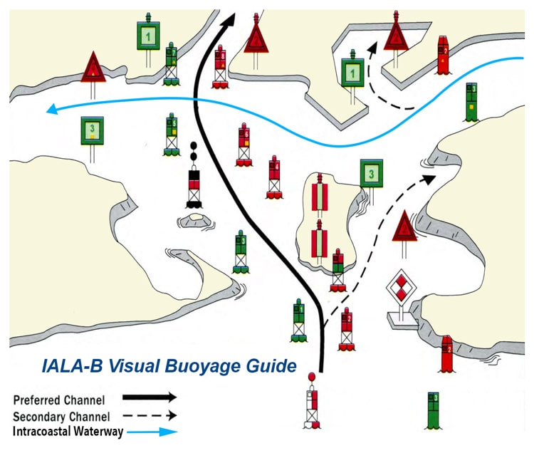
Daytime Channel
Cardinal Marks
Various countries also use cardinal marks. While not prevalent in the USA, you will see them in other places, including the Caribbean.
Cardinal marks tell you on which side there is safe passage around a hazard. For example, a North Cardinal mark will tell you to pass to the north of the mark for safe passage.
|
Cardinal Marker
|
Image
|
For safe passage
pass to the… |
Distinguishable by…
|
Picture
|
| North Cardinal | 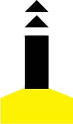
|
North | The two arrows at the top point up towards the top of the compass. Black support tube. | 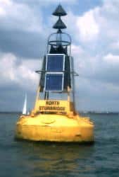
|
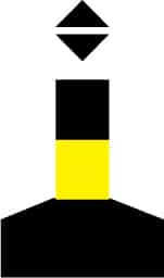
| South Cardinal | 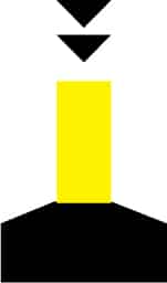
|
South | The two arrows at the top point down towards the bottom of the compass. Yellow support tube. | 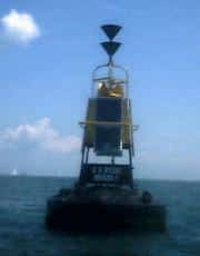
|
|
East Cardinal |
|
East | The two arrows at the top point away from each other. Kind of looks like an egg (?) then remember by Easter Egg. | 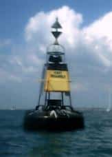
|
| West Cardinal | 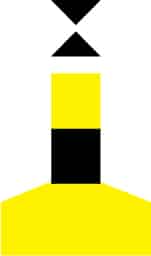
|
West | The two arrows at the top point toward each other. Notice that the sideways shape is kind of like a W. | 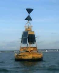
|
Or in summary…
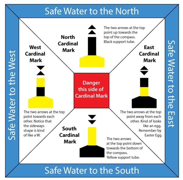
Cardinal Marks
You can learn more in the Skipper Course....
Knowledge and theory for longer distances and overnight sailing in diverse conditions. The Skipper Course is a comprehensive online sailing course for beginner to intermediate sailors wanting to learn how to sail larger sailboats 26ft to 56ft. Or upgrade to the Skipper Course Bundle of online courses to also master maneuvering under power and docking!